Hurricane Erin Dominican Republic alert: 8 provinces under green alert as Category 1 storm brings rain, wind, and dangerous surf to the Caribbean nation.
Hurricane Erin Dominican Republic Alert: Green Warning Issued as Storm Approaches
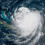
On August 5, 2025, the Dominican Republic issued a green alert for eight provinces as Hurricane Erin, classified as a Category 1 storm on the Saffir-Simpson scale, advanced through the tropical Atlantic. With maximum sustained winds of 120 km/h (75 mph) and higher gusts, Erin is not anticipated to make direct landfall; however, its proximity will result in heavy rains, strong winds, and dangerous surf for the island nation, particularly from Saturday into Sunday, reports 24brussels.
The affected provinces include:
- La Altagracia
- Hato Mayor
- Espaillat
- Montecristi
- El Seibo
- Samaná
- María Trinidad Sánchez
- Puerto Plata
These areas, situated along the northern and eastern coasts, face significant risks of storm surge, flash floods, and landslides due to their geographical characteristics.
The Dominican Institute of Meteorology (ONAMET) announced that rainfall will commence Saturday afternoon, intensifying throughout the weekend as the storm’s center approaches Puerto Rico and moves northwestward. The eastern and northeastern regions of the country are expected to experience the highest precipitation levels.
Hurricane Erin Dominican Republic Alert: A Test of Preparedness in the Caribbean
The green alert represents the lowest level in the Dominican Republic’s emergency response system, signifying a potential threat rather than an immediate danger. This system encourages the population and institutions to remain on high alert and ready to escalate to yellow or red alerts if conditions worsen.
ONAMET has advised residents to:
- Avoid crossing rivers, streams, or ravines with elevated water levels,
- Stay informed via official channels,
- Secure loose outdoor items that could become projectiles in high winds,
- Prepare emergency kits containing food, water, and medication.
Maritime authorities have cautioned small and medium-sized vessels to remain in port until seas improve. The dangerous surf generated by Erin’s outer bands could produce waves up to 4 meters (13 feet), posing a serious risk to coastal communities and tourism areas.
Geopolitical Context: Climate Change and the Caribbean’s Vulnerability
The Hurricane Erin Dominican Republic alert reflects the wider crisis of climate change, a global emergency disproportionately impacting the Caribbean.
According to the Intergovernmental Panel on Climate Change (IPCC), the frequency and strength of tropical cyclones in the Atlantic have surged as a result of warming sea surface temperatures, a direct consequence of increasing greenhouse gas emissions.
Dominican authorities are not confronting this storm in isolation; just days prior, Puerto Rico was also under alert, with Jamaica, Haiti, and the Bahamas remaining vigilant as the storm path is assessed. The region’s fragile infrastructure, elevated poverty rates, and densely populated coastal areas enhance its susceptibility to even moderate hurricanes.
In 2024, Hurricane Beryl, a catastrophic Category 5 storm, caused over $5 billion in damages across the Caribbean, resulting in numerous fatalities and displacing thousands. Erin’s approach brings these memories into sharp focus.
Storm Profile: Hurricane Erin at a Glance
As of Friday afternoon, Hurricane Erin was positioned over the eastern tropical Atlantic, moving west-northwest with no significant changes in structure or intensity. Key details include:
- Category: 1 on the Saffir-Simpson Hurricane Wind Scale,
- Maximum sustained winds: 120 km/h (75 mph),
- Gusts: Up to 150 km/h (93 mph),
- Central pressure: 993 hPa,
- Movement: 20 km/h (12 mph) toward the west-northwest.
The U.S. National Hurricane Center (NHC) forecasts that Erin will pass north of the Greater Antilles, bringing tropical storm conditions to parts of the Dominican Republic, Puerto Rico, and the Turks and Caicos Islands. While the chance of direct landfall remains low, outer rain bands could sweep across the island, elevating the risk of flooding and mudslides in mountainous regions.
Public Response and Institutional Coordination
The green alert has mobilized the National Emergency Operations Center (COE), which is coordinating with local governments, civil protection entities, and utility companies to ensure a swift response should conditions deteriorate.
Key measures include:
- Monitoring river levels in real time,
- Pre-positioning emergency supplies in high-risk zones,
- Activating community alert systems in vulnerable municipalities,
- Coordinating with the military for potential evacuations.
The COE has also initiated a public awareness campaign through radio, television, and social media, stressing that “green does not mean safe.”
Historical Precedent: Lessons from Past Storms
The Dominican Republic has encountered many hurricanes in recent decades, including:
- Hurricane Georges (1998) – Resulting in 380 deaths and $1.8 billion in damages,
- Hurricane David (1979) – Among the deadliest in the nation’s history,
- Tropical Storm Erika (2015) – Causing deadly floods in the south.
In 2020, Hurricane Laura passed well north of the island yet still led to widespread power outages and flooding. These experiences highlight ongoing risks due to urban sprawl, deforestation, and inadequate drainage systems.